Integrating In-Built LiDAR and Remote Sensing Tools for Effective LiDAR Data Management and Manipulation in a GIS Software Environment
Published on: 19.07.2024
One of the primary challenges why GIS software often don’t integrate LIDAR tools, lies in handling the massive datasets generated by LiDAR and Remote Sensing technology. These datasets consist of millions of data points, resulting in large volumes of data that can be cumbersome to manage and process.
For any GIS platform to effectively integrate LiDAR tools, it must possess the capability to handle such vast datasets without compromising performance. This entails efficient data storage, robust data management capabilities, and sufficient computing resources available to users. Additionally, the development of efficient algorithms tailored for processing LiDAR data is crucial for ensuring smooth integration and optimal performance.
In essence, while the integration of LiDAR tools into GIS software offers significant benefits, overcoming challenges related to data volume, storage, management, and computational efficiency remains critical for seamless functionality.
Let’s review the procedure in the emerging Green Software Technology.
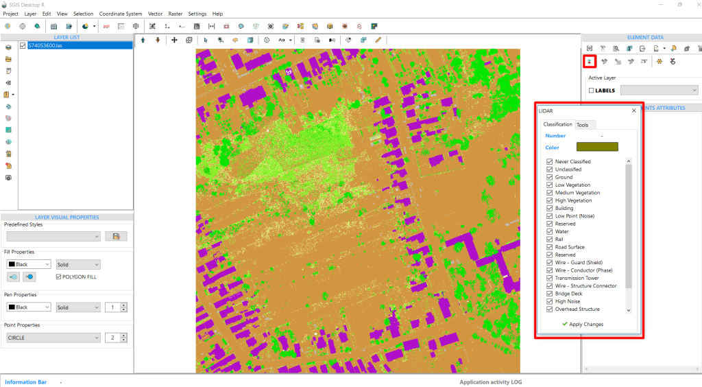
The LAS file is opened using a straightforward “Open LAS” command:
Fig.1 A LAS file opened in SGIS Desktop v.R
In the element data panel located in the upper right corner of the user interface, there is a LIDAR tool. Activating it opens a new window featuring a classifications panel with tools to manage them.
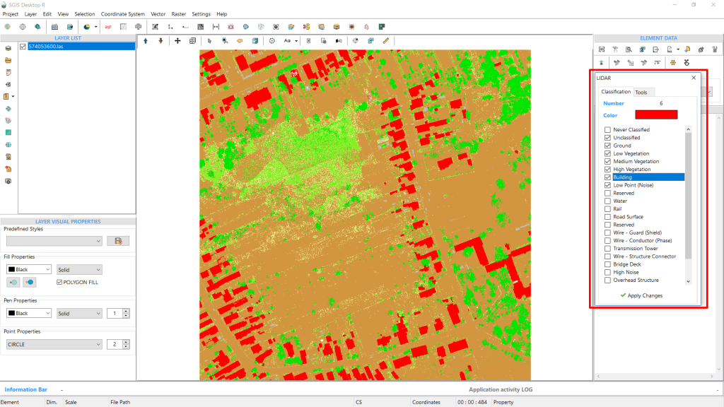
To remove the default list and preview only the actual existing classifications, we’ll use the ‘Uncheck Non-Existing Classifications’ function.
This one-click function automatically unchecks all classifications not contained in the file, leaving only the existing ones.
Fig.2 Clicking the LIDAR data button brings up the LIDAR data management toolbox.
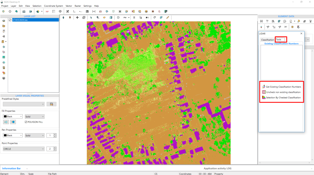
Here’s how the toolbox appears when you select the ‘Tools’ tab:
Fig.3 Inside the 'Tools' tab, there's a list of tools where users can find the 'Uncheck Non-Existing Classifications' function.
The ‘Uncheck Non-Existing Classifications’ tool enables users to select or deselect multiple checkboxes with a single click. This feature eliminates the need for users to manually uncheck each checkbox individually. While users still have the option to manually manage checkboxes, this tool provides a convenient way to expedite data processing tasks, especially when speed is essential.
Fig.4 Displaying the seven active classifications, with the others removed.
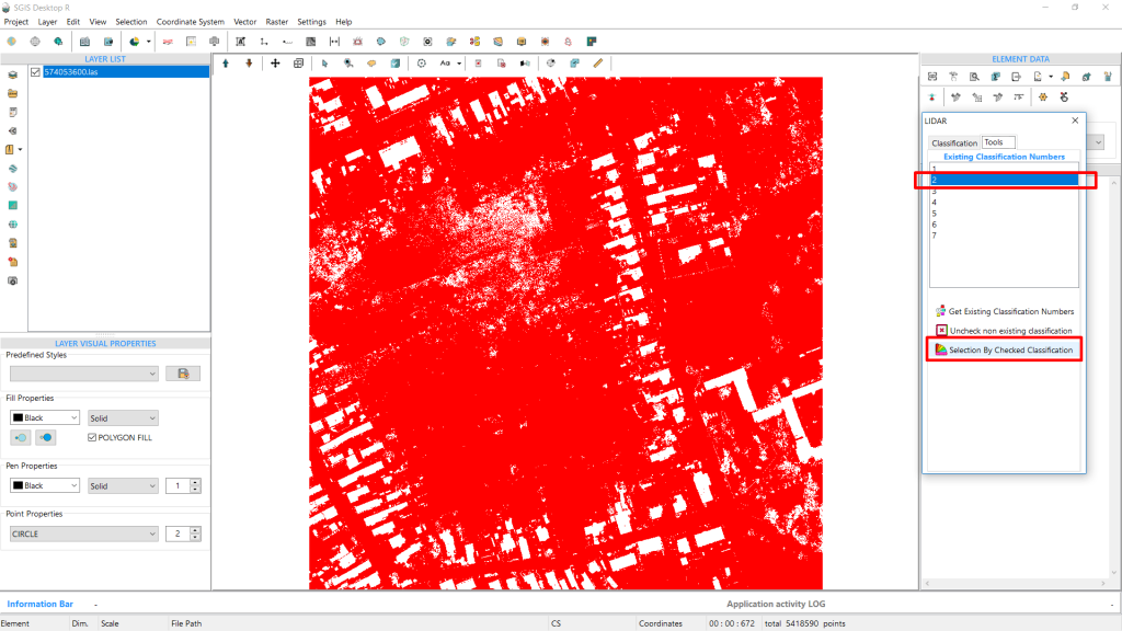
In the tools tab, you’ll find additional functions that are quite useful. The first tool is ‘Get Existing Classification Numbers,’ and the third on the list is ‘Selection By Checked Classification.’ These tools are designed to streamline user’s workflow.
When you click on ‘Get Existing Classification Numbers,’ it retrieves and displays the classification numbers in a panel box, each representing a specific type of data, such as unclassified points, ground points, or buildings. Users can then select any classification number from the panel and use the ‘Selection By Checked Classification’ tool. This will highlight all points of the chosen classification in the graphics panel.
Fig.5 Classification number 2 representing ground points is selected from the toolbox and displayed (highlighted) in the graphics panel
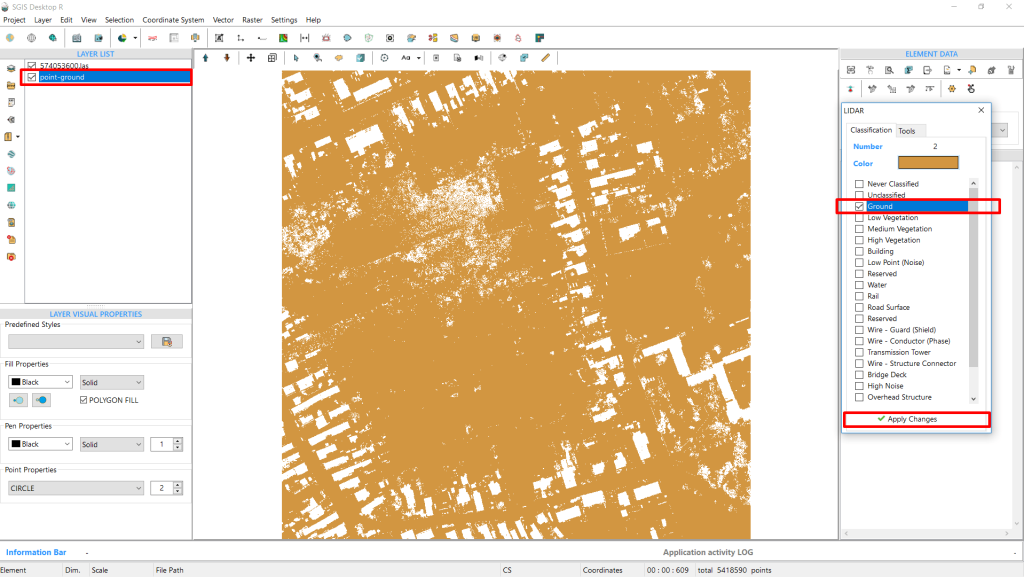
Fig.6 Ground points isolated into new GIS layer for further processing
Since the graphics panel is interconnected, we can easily use the ‘Selection in a New Layer’ function to isolate ground points or any other classification from the LAS file into a new GIS layer. The new layer will automatically appear in the layers panel list, allowing us to export it as a separate file, create a grid layer, generate a DEM, or save it as a text file. This toolset significantly simplifies the process of managing and manipulating LiDAR data.
What’s important here is that SGIS v.R technology and its algorithms are entirely original, without relying on external libraries or applications like PDAL and others.
So, to effectively manage LIDAR data, a GIS platform should:
Handle large datasets without performance issues.
Manage high-resolution data smoothly without lag.
Require technical expertise in both LIDAR and GIS technologies for developers and users to manipulate data correctly and implement the appropriate code effectively.