Development of an Optimized Algorithm for the Simultaneous Subdivision of Multiple Land Parcels in a GIS Environment, with Automatic Assignment of Sequential Land Parcel Numbers
Published on: 23.08.2024
General
Land Parcel Subdivision is a critical aspect of land surveying and cadastre, involving the legal modification of property boundaries in compliance with local standards and regulations. This process entails dividing a parcel or allotment into smaller lots, each with its own title deed, typically for purposes such as sale, residential development, or ownership transfer.
Given that ownership and parcel characteristics frequently change, it is essential to continuously update the cadaster to align with ongoing subdivision practices.
Land parceling and cadastre updates are not one-time tasks; they are continuous processes because ownership is constantly transferred between legal entities.
Therefore, the ongoing process of subdividing parcels for sale, development, or transfer is crucial and enduring. Each land parcel has legally defined boundaries, documented according to the specific regulations of the country.
Introduction
In our example involving an expropriation line, we illustrate the importance of land acquisition for infrastructure projects.
Expropriation is the process of resolving property and legal issues related to real estate, such as land and buildings, in connection with the implementation of infrastructure projects.
Infrastructure projects include structures of public interest, such as roads, railways, canals, water supply systems, oil pipelines, sewage systems, gas pipelines, and electrical infrastructure, which may be located either above ground or underground.
To carry out these projects, the boundaries of the designed structure are overlaid onto the cadastral map. This overlap of the existing cadastral state with the projected future state is necessary, to facilitate the sale of land parcels or portions thereof that fall within the boundaries of the planned infrastructure. Such transactions are in the interest of both the project investors and the landowners affected by the construction.
Most infrastructure projects require a continuous piece of land, meaning these projects are typically extensive, crossing multiple parcels and affecting numerous property segments which are often privately owned. Because of this, specialized legal regulations are in place for projects deemed to be of common interest. Without the expropriation process, any landowner could potentially halt the project by refusing to sell or by demanding an unjustifiably high price. Therefore, the expropriation process, and its connection to the land cadastre, is vital for the successful implementation of these projects.
We aim to demonstrate, through a simple example, how SGIS’s algorithm is designed and optimized for fast and efficient performance, particularly given the complexity of the process and the critical importance of the data and outcomes.
This procedure involves dividing the entire project area in one comprehensive process, rather than simply dividing a single parcel into two parts.
In addition, this algorithm not only accurately divides the geometry but is also optimized to recognize and update the attribute table. When a land parcel division is processed in SGIS, the algorithm automatically fills in the attribute table with new area measurements and assigns new numerical labels as Land Parcel Numbers.
In North Macedonia’s official cadastre, the Land Parcel Number is an officially recognized attribute field, included in the data purchased by companies. What makes our algorithm particularly significant is its ability to preserve the historical lineage of cadastral data. When assigning new parcel numbers—such as when a single parcel is divided into two smaller lots—the algorithm does not generate random numbers. Instead, it retains the original number for one lot and assigns a sequential number to the second lot. This approach maintains the continuity and traceability of the land registry system, making it easy to identify the pattern of parcel divisions.
The algorithm is designed to handle this process for any number of parcels simultaneously.
Now, let’s begin with the example.
A Practical Example
Fig.1 Data Imported into SGIS v.R.
Fig.2 A dataset with Land Parcels and an expropriation buffer has been imported into SGIS v.R. The buffer intersects multiple parcels, requiring Parcel Division to compare the current and proposed states.
We have imported a dataset into SGIS v.R that includes Land Parcels and a buffer polygon representing the expropriation area. This buffer intersects multiple parcels, affecting various landowners. To prepare a parcelation report, we need to perform Parcel Division, which will provide a comparison between the current state and a proposed new state. Parcel numbers, which are stored in the attribute field PARCNO (a field created by the official government agency for real estate cadastre), are labeled and made visible on the map.
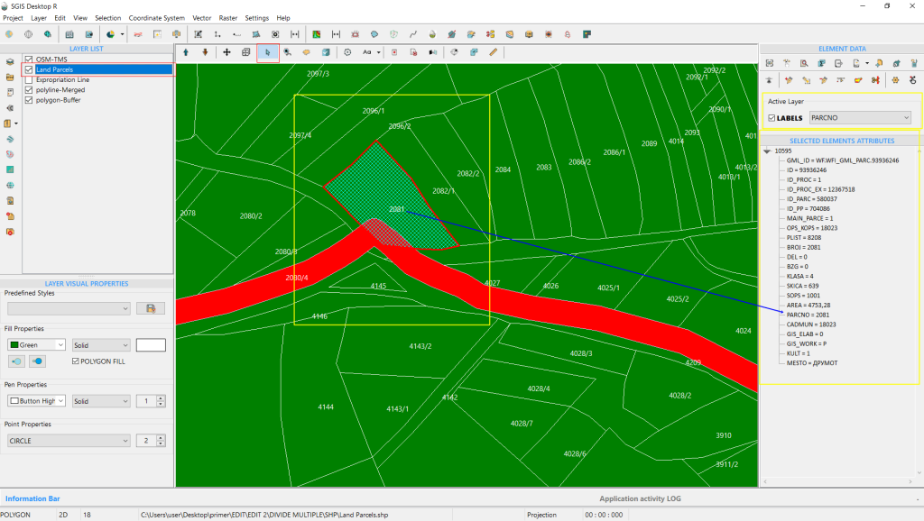
Fig.3 Parcel Number 2081 is selected, with its attribute values displayed in the ‘Selected Element Attributes’ panel.
Fig.4 The expropriation buffer affects multiple land parcels. Selecting a parcel displays its attribute data, including area, cadastral municipality, parcel number, land class, and ownership details.
As shown, multiple land parcels are impacted by the expropriation buffer.
When a parcel is selected, its attribute data is displayed, including its area, cadastral municipality, parcel number, land classification, and ownership details.
Fig.5 Selected parcel attribute data displayed, including area, cadastral municipality, parcel number, land classification, and ownership details.
In this process, we focus on dividing multiple land parcels based on a predefined condition layer, rather than using algorithms that divide by proportional areas or distances. This condition layer is established by professionals for purposes such as the realization of project documentation or urban plans.
The boundaries are carefully checked and drawn based on accurate project documentation.
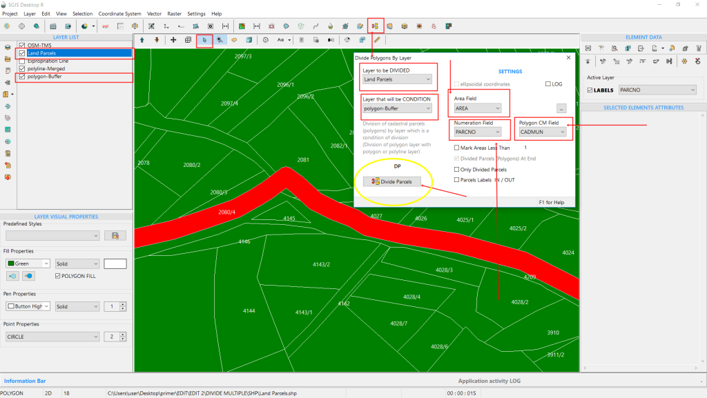
Fig.6 The ‘Divide Parcels’ function is activated, and the settings for configuration are displayed.
To ensure a smooth process, we first configure the settings in a new dialog box.
Here’s how:
Select Layer to Divide: Choose the layer you want to divide from the dropdown list. We select the “Land Parcels” layer.
Set Condition Layer: This determines how the layer will be divided. Our condition layer is the buffer layer, which was created based on the expropriation line and includes a 10-meter buffer on each side, drawn precisely by professionals.
Define Field for New Areas: Specify the attribute field where the newly created polygon areas will be stored. We use the “Area” field for this purpose.
Set Numeration Field: This field will store both the original and new parcel numbers for the subdivided lots. It’s crucial for tracking parcel numbers accurately.
Configure Polygon CM Field: This field helps differentiate polygons, especially in projects spanning multiple cadastral municipalities. We select “CADMUN” (Cadastral Municipality) to ensure unique parcel identification across different municipalities.
Once these settings are configured, click ‘Divide Parcels’ to proceed.
Fig.7 The division process is completed quickly, as shown in the ‘Parcel Division’ dialog box. The new layer, ‘polygon-DP,’ is created, preserving the original layer. Adjust the new layer's color and settings as needed.
The division process completes in less than a second, as shown in the information ribbon within the ‘Parcel Division’ dialog box. This feature helps users track the time taken for the procedure.
The operation creates a new layer, preserving the original layer intact. All changes are made on the new layer, which appears in the Layers panel as ‘polygon-DP’.
You can adjust its color and visual settings to your preference before continuing.
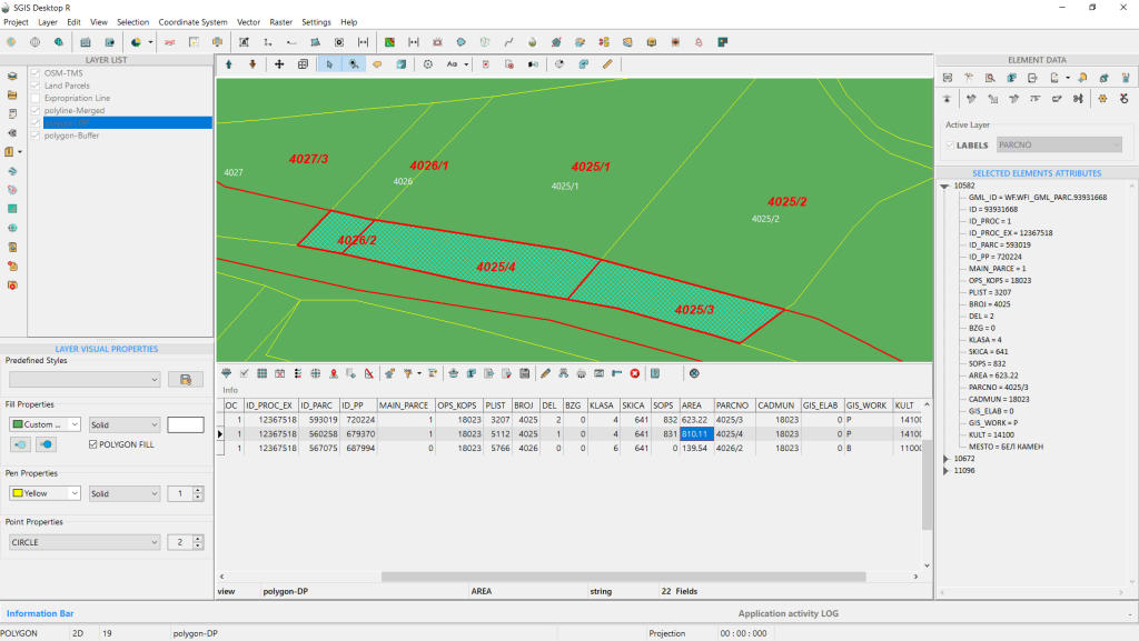
Fig.8 Click on the newly subdivided parcels in the new layer to view and verify their attributes.
Fig.9 Checking the attributes of the newly created land parcels.
Fig.10 Selecting and inspecting the newly created parcels on the graphics panel.
After completing the procedure, the next step is to export the attribute data for preparing the geodetic report. SGIS simplifies this process by allowing users to export either the entire attribute table or selected features into a CSV file, ready for further processing.
This capability streamlines a task that traditionally required significant time and effort from multiple people, now achievable in just minutes by a single person.
Fig.11 Parcel 4025/2 is divided by a red buffer line, with the original number 4025/2 shown in white. The new DP layer assigns numbers 4025/2 and 4025/3, maintaining historical lineage.
In Fig.11, we see the parcelation of the land parcel numbered 4025/2. The parcel is divided by a red buffer line, with the original number 4025/2 highlighted in white. In the new DP layer, the subdivided parcels are numbered 4025/2 and 4025/3. The original number is retained for the larger portion, while the expropriated section is assigned the new number 4025/3. This method preserves the historical lineage of the parcel, indicating that the newly numbered section was originally part of the larger parcel. This approach is crucial for maintaining the accuracy and continuity of land cadastre and registry systems.
Fig.12 The procedure is complete and the data is ready for further processing and geodetic reporting.
The procedure is now complete.
Conclusion
This method of dividing multiple parcels is designed for processes such as expropriation, urban plan implementation, or any situation where there is an existing cadastral state that needs to be updated to reflect a projected state. Based on the cadastral registry, each landowner will receive appropriate compensation for the acquisition of their land.
Traditionally, this process is done one parcel at a time, but with our algorithm, it is completed simultaneously for all parcels. This approach maintains accuracy, precision, and data integrity while significantly reducing time and resource requirements.