
Green Information Technology Green IT
Green IT Green Information Technology
SGIS TECHNOLOGY INITIATIVE
THE GENESIS OF SGIS TECHNOLOGY AND PRODUCTS

We prioritize environmental sustainability in our development process.
When it comes to GIS technology and projects, we often deal with vast amounts of data—commonly referred to as big data. Big data is characterized by its volume, velocity, and variety, meaning large quantities of data are generated quickly and come in various formats (Big data and GIS, n.d.). Although GIS data and big data are not identical, they are closely related and frequently integrated. When combined, GIS and big data offer powerful insights into a multitude of real-world challenges. Examples of big data sources include satellite images and extensive graphical data containing complex attributes and metadata.
The rise of big data has revolutionized every industry – GIS is no exception. This shift has significantly changed how we acquire and use spatial information. Organizations are increasingly using geographic information science and technology. While government agencies were historically the main users of geospatial data, today, businesses across all sectors are adopting GIS at a rapid pace.
The most critical aspect of developing GIS technology is ensuring it can effectively manage these types of big data. This capability is fundamental to the success and efficiency of any GIS project.
Traditionally, we measure algorithm efficiency by how well it solves problems and how much computing power and storage it requires.
But with energy becoming a costly and limited resource, there’s a new focus on the environmental footprint of algorithms. This shift reflects a broader awareness of energy’s importance and prompts us to rethink how algorithms are designed and used.
RELYING ON THIRD-PARTY CODE LIBRARIES
One important aspect of green software development is creating innovative solutions with original algorithms that are entirely independent of external libraries. Unlike most GIS software that relies on frameworks like GDAL, PROJ, .NET, and JAVA runtime environments, green software development emphasizes self-sufficient algorithms.
Why is that?
When you add a third-party library, you’re taking on responsibility for code you didn’t write. This can introduce potential liabilities and complexities. Every new piece of code increases overhead, whether in load time or complexity.
Third-party libraries often contain more code than necessary because they’re designed to handle a wide range of use cases. This extra, unused code can make your project more cumbersome and introduce more opportunities for bugs. Plus, each library may have its own dependencies, creating a complex web of code to manage and maintain.
WHY ALGORITHMS MATTER FOR EFFICIENCY?
In the context of all GIS tasks, aligning with Green IT and Green Software Development means:
- Reduce Computational Complexity: Energy-efficient algorithms focus on simplifying computational tasks. By minimizing time and space complexity, these algorithms require fewer resources and consume less energy during operation.
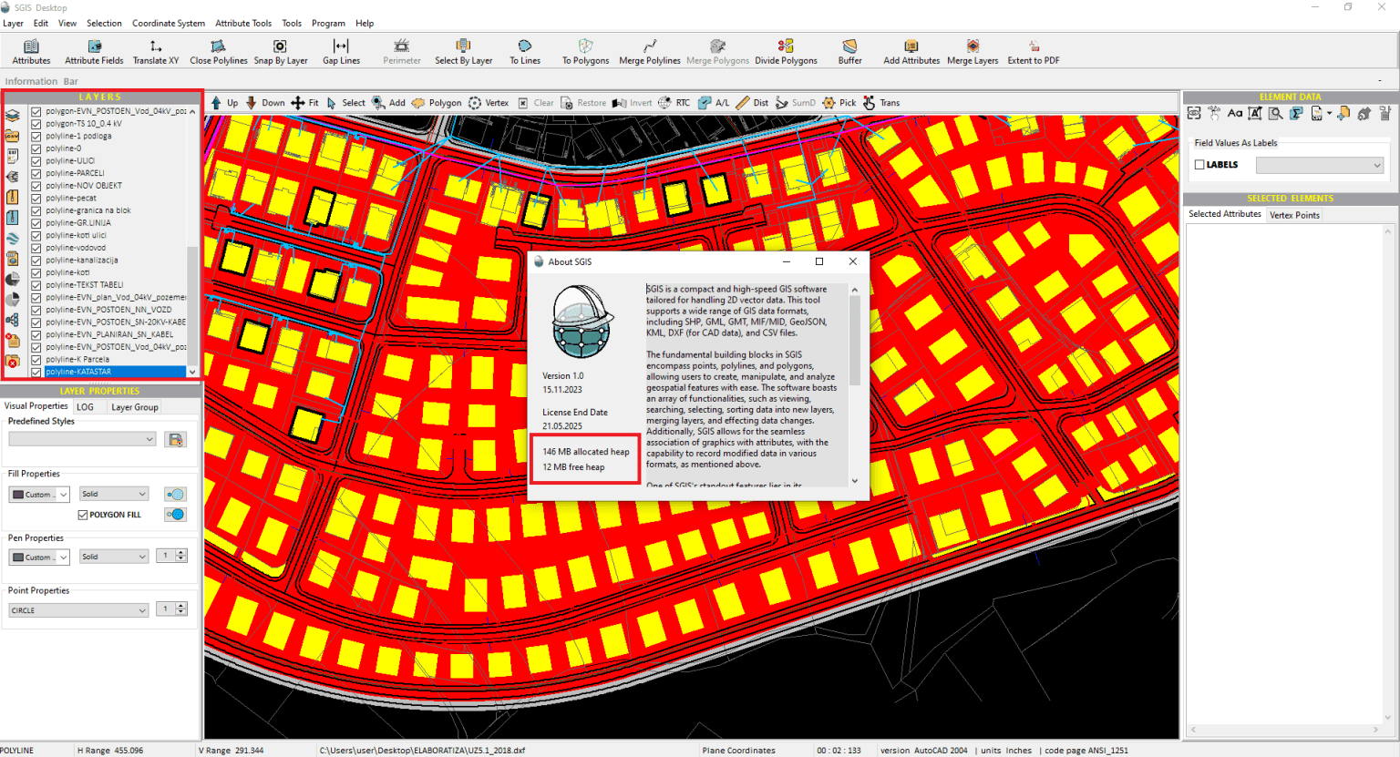
- Optimize Memory Use: Efficient data structures are smart about using memory. By keeping the memory footprint small and improving the way memory is accessed, these structures can significantly cut down the energy needed for memory operations like reading and writing. SGIS’s technology, exemplified throughout various tasks and case studies, is optimized for minimal storage usage. When using SGIS Desktop v1.0 with multiple data layers open, the system displays an allocated heap size of 146 MB, with 12 MB of free heap available. This information allows users to monitor memory usage and manage resources effectively within the software. For comparison, you can open your task manager to see how much storage a basic browser like Google Chrome consumes during use.
- Minimizing Data Redundancy: Reducing data redundancy and optimizing data storage solutions to lower the amount of storage required and the associated energy usage.
- Leveraging Renewable Energy: Where possible, using renewable energy sources to power the systems and data centers involved in processing GIS data.
- Sustainable Practices in Software Design: Designing the software to be energy-efficient, minimizing the need for frequent updates or upgrades, and ensuring compatibility with existing hardware to extend its lifespan.
Our software is designed to minimize resource consumption, reducing the need for frequent hardware upgrades that contribute to environmental pollution.
SGIS Desktop is optimized for minimal storage usage while delivering swift performance across various computer setups.
It operates smoothly on Windows 7, 8, 10, and 11 (both 32 and 64-bit versions), and Linux, with a minimum of 2 GB RAM.
We are currently working on integrating the technology on MacOS.
This careful engineering ensures maximum capabilities with minimal hardware demands.
Efficient algorithms in SGIS Desktop help streamline processes, cutting down on the need for excessive computing power and reducing energy use. The software’s precision tools for cadastral, infrastructure, and geospatial data editing are built to be efficient. On the other hand, inefficient algorithms can increase energy demands and waste resources, highlighting the need for eco-friendly solutions. SGIS Desktop is dedicated to precision and efficiency, making sure these concerns are always a priority.
What is Green IT?

Green IT, or Green Information Technology, focuses on environmentally sustainable computing. It encompasses practices and strategies that reduce the ecological footprint of IT systems. This includes energy-efficient hardware, virtualization to minimize physical devices, e-waste management, and promoting eco-friendly software development. The goal is to minimize energy consumption, reduce carbon emissions, and manage e-waste effectively. Implementing Green IT not only benefits the environment but can also lead to cost savings and improved corporate sustainability.
